



Las Vegas Strip Map
It’s interactive! Point or tap on anything
for more info, and to see what used to be there.
You might prefer the compact map.
Find your hotel/etc: Gone:

I-15
Highway I-15 continues to downtown.
So does the CX bus from the airport which takes the highway.
Highway I-15 continues to downtown.
So does the CX bus from the airport which takes the highway.
The Strip
The portion of South Las Vegas Boulevard from the Strat Tower to Mandalay Bay is known as the Las Vegas Strip.
If you continue north on S. Las Vegas Blvd. for about 1.5 miles, you wind up downtown, which is the other main casino area of Vegas.
The portion of South Las Vegas Boulevard from the Strat Tower to Mandalay Bay is known as the Las Vegas Strip.
If you continue north on S. Las Vegas Blvd. for about 1.5 miles, you wind up downtown, which is the other main casino area of Vegas.
PARADISE ROAD
Paradise Rd. is depicted on our map in red, with the important bus stops for the #108 bus marked with dots (though there are many other stops). Paradise ends near the top of the map where the bus turns left onto St. Louis. Point to or tap the bus at the airport for more info about the #108 bus.
Paradise Rd. is depicted on our map in red, with the important bus stops for the #108 bus marked with dots (though there are many other stops). Paradise ends near the top of the map where the bus turns left onto St. Louis. Point to or tap the bus at the airport for more info about the #108 bus.
This indicates that I-15, the CX bus, S.
Las Vegas Blvd, and the #108 bus all continue to Downtown
(Fremont Street Experience).
Desert Inn Road is named after the
Desert Inn hotel/casino, which is where Wynn/Encore now
sits. It’s not a posthumous renaming; Desert Inn casino
closed in 2000 but the road bore its name for decades before
that.
Sands Avenue got its name from the
Sands hotel/casino which was where the Venetian now
stands. The Sands closed in 1996. It’s not a
posthumous renaming; the street has been Sands Avenue since the
1950s.
Tropicana Avenue is named after the
Tropicana hotel/casino, which closed in 2024. It’s not a
posthumous renaming; it’s been Tropicana Ave. since 1961.
STRAT BUS STOP
(Bus #108.) Get off the bus here (next to the Denny’s) for the Strat if you’re going northbound. The #108 runs about every 30 minutes. schedule
(Bus #108.) Get off the bus here (next to the Denny’s) for the Strat if you’re going northbound. The #108 runs about every 30 minutes. schedule
STRAT BUS STOP
(Bus #108.) Get off the bus here for the Strat if you’re going soutbound (from Downtown). The #108 runs about every 30 minutes. schedule
(Bus #108.) Get off the bus here for the Strat if you’re going soutbound (from Downtown). The #108 runs about every 30 minutes. schedule
Sahara #108 bus stop (northbound)
Get off the bus here for Sahara, Bonanza Gift Shop (world’s largest), and connection to the Monorail. The #108 runs about every 30 minutes. schedule
Get off the bus here for Sahara, Bonanza Gift Shop (world’s largest), and connection to the Monorail. The #108 runs about every 30 minutes. schedule
Sahara #108 bus stop (southbound)
Get off the bus here for Sahara, Bonanza Gift Shop (world’s largest), and connection to the monorail. The #108 runs about every 30 minutes. schedule
Get off the bus here for Sahara, Bonanza Gift Shop (world’s largest), and connection to the monorail. The #108 runs about every 30 minutes. schedule
Westgate #108 bus stop
(northbound)
Get off the bus here for Westgate, convention center West Hall, and connection to the monorail. The #108 runs about every 30 minutes. schedule
Get off the bus here for Westgate, convention center West Hall, and connection to the monorail. The #108 runs about every 30 minutes. schedule
Westgate #108 bus stop
(soutbound)
Get off the bus here for Westgate, convention center, West Hall, and connection to the monorail. The #108 runs about every 30 minutes. schedule
Get off the bus here for Westgate, convention center, West Hall, and connection to the monorail. The #108 runs about every 30 minutes. schedule
#108 bus stop
(northbound)
Get off here for the convention center. The #108 runs about every 30 minutes. schedule
Get off here for the convention center. The #108 runs about every 30 minutes. schedule
#108 bus stop
(southbound)
Get off here for the convention center, South Hall. The #108 runs about every 30 minutes. schedule
Get off here for the convention center, South Hall. The #108 runs about every 30 minutes. schedule
#108 bus stop
(northbound)
Get off here for the convention center, South Hall. The #108 runs about every 30 minutes. schedule
Get off here for the convention center, South Hall. The #108 runs about every 30 minutes. schedule
#108 bus stop
(northbound)
Get off here for the convention center, South Hall. The #108 runs about every 30 minutes. schedule
Get off here for the convention center, South Hall. The #108 runs about every 30 minutes. schedule
Sphere #108 bus stop (southbound)
Get off here for Sphere when traveling southbound on the #108. The northbound #108 doesn't stop at the Sphere. The bus runs about every 30 minutes. schedule
Get off here for Sphere when traveling southbound on the #108. The northbound #108 doesn't stop at the Sphere. The bus runs about every 30 minutes. schedule
#108 bus stop (southbound)
Get off the #108 southbound here for Silver Sevens. The northbound bus doesn’t stop at Silver Sevens. The bus runs about every 30 minutes. schedule
Get off the #108 southbound here for Silver Sevens. The northbound bus doesn’t stop at Silver Sevens. The bus runs about every 30 minutes. schedule
VIRGIN #108 bus stop
Get off the #108 southbound here for Virgin. The #108 runs about every 30 minutes. schedule
Get off the #108 southbound here for Virgin. The #108 runs about every 30 minutes. schedule
VIRGIN #108 bus stop
Get off the #108 southbound here for Virgin. The #108 runs about every 30 minutes. schedule
Get off the #108 southbound here for Virgin. The #108 runs about every 30 minutes. schedule
VIRGIN #108 bus stop
Get off the #108 northbound here for Virgin. It’s about a 5-minute walk. The #108 runs about every 30 minutes. schedule
Get off the #108 northbound here for Virgin. It’s about a 5-minute walk. The #108 runs about every 30 minutes. schedule
CX bus stop
The CX starts at the airport, stops at the Strip between Horseshoe and Cromwell, and again at Bellagio, then continues to downtown as an express. It runs every 45-60 minutes. schedule
The CX starts at the airport, stops at the Strip between Horseshoe and Cromwell, and again at Bellagio, then continues to downtown as an express. It runs every 45-60 minutes. schedule
CX bus stop
The CX starts at the airport, stops at the Strip between Horseshoe and Cromwell, and again at Bellagio, then continues to downtown as an express. It runs every 45-60 minutes. schedule
The CX starts at the airport, stops at the Strip between Horseshoe and Cromwell, and again at Bellagio, then continues to downtown as an express. It runs every 45-60 minutes. schedule
CX bus stop
The CX starts at the airport, stops at the Strip between Horseshoe and Cromwell, and again at Bellagio, then continues to downtown as an express. It runs every 45-60 minutes. schedule
The CX starts at the airport, stops at the Strip between Horseshoe and Cromwell, and again at Bellagio, then continues to downtown as an express. It runs every 45-60 minutes. schedule
CX bus stop
The CX starts at the airport, stops at the Strip between Horseshoe and Cromwell, and again at Bellagio, then continues to downtown as an express. It runs every 45-60 minutes. schedule
The CX starts at the airport, stops at the Strip between Horseshoe and Cromwell, and again at Bellagio, then continues to downtown as an express. It runs every 45-60 minutes. schedule
CX bus stop
The CX starts at the airport, stops at the Strip between Horseshoe and Cromwell, and again at Bellagio, then continues to downtown as an express. It runs every 45-60 minutes. schedule
The CX starts at the airport, stops at the Strip between Horseshoe and Cromwell, and again at Bellagio, then continues to downtown as an express. It runs every 45-60 minutes. schedule
CX bus stop
The CX starts at the airport, stops at the Strip between Horseshoe and Cromwell, and again at Bellagio, then continues to downtown as an express. It runs every 45-60 minutes. schedule
The CX starts at the airport, stops at the Strip between Horseshoe and Cromwell, and again at Bellagio, then continues to downtown as an express. It runs every 45-60 minutes. schedule
Route 108 bus
Point to or click on the picture of the bus at the airport for more info.
Point to or click on the picture of the bus at the airport for more info.
Centennial Express Bus
Point to or click on the picture of the bus at the airport for more info.
Point to or click on the picture of the bus at the airport for more info.
The CX leaves from the airport,
stops right on the Strip between Horseshoe and Cromwell, and
again at Bellagio, then continues to Downtown as an
express. It runs about every 45-60 minutes. schedule
The #108 stops at Virgin, Silver Sevens, the Sphere, the Convention Center, Sahara, and The Strat, then continues to downtown. It runs about every 30 minutes. schedule
The double-decker Deuce bus runs up and down the strip every 10-15 minutes (and every 20 minutes overnight). It also goes between the Strip and Downtown (but not to/from the airport). It's the generally the best way to get around the Strip. It's not depicted on the map because the route is simple and it stops everywhere.
FARES: $4 single ride • $6 for 2hr pass • $8 for 24hr pass • $20 for 3d pass (fares as of 12/14/23; fare website)
The #108 stops at Virgin, Silver Sevens, the Sphere, the Convention Center, Sahara, and The Strat, then continues to downtown. It runs about every 30 minutes. schedule
The double-decker Deuce bus runs up and down the strip every 10-15 minutes (and every 20 minutes overnight). It also goes between the Strip and Downtown (but not to/from the airport). It's the generally the best way to get around the Strip. It's not depicted on the map because the route is simple and it stops everywhere.
FARES: $4 single ride • $6 for 2hr pass • $8 for 24hr pass • $20 for 3d pass (fares as of 12/14/23; fare website)
Sahara Monorail Station
The Sahara station is the last stop on the Monorail (or the first station, depending on your perspective). Sahara is literally right across the street from the station.
The Sahara station is the last stop on the Monorail (or the first station, depending on your perspective). Sahara is literally right across the street from the station.
WESTGATE STATION
...of the Monorail
...of the Monorail
Boingo Station
...of the Monorail, at the Convention Center
...of the Monorail, at the Convention Center
Harrah’s / Line Station
...of the Monorail
...of the Monorail
Flamingo/Caesars Palace
Station
...of the Monorail
...of the Monorail
HORSESHOE/PARIS STATION
...of the Monorail
...of the Monorail
MGM STATION
...of the Monorail
...of the Monorail
TESLA TUNNEL
aka "Convention Center Loop", "Vegas Loop".
Free from stations marked with a blue dot.
$4 one-way / $6.25 round-trip from stations marked with a black dot.
aka "Convention Center Loop", "Vegas Loop".
Free from stations marked with a blue dot.
$4 one-way / $6.25 round-trip from stations marked with a black dot.
RESORTS WORLD STATION
aka "Convention Center Loop", "Vegas Loop".
Free from stations marked with blue dot.
$4 one-way / $6.25 round-trip from stations marked with a black dot.
aka "Convention Center Loop", "Vegas Loop".
Free from stations marked with blue dot.
$4 one-way / $6.25 round-trip from stations marked with a black dot.
RIVIERA STATION
aka "Convention Center Loop", "Vegas Loop".
Free from stations marked with blue dot.
$4 one-way / $6.25 round-trip from stations marked with a black dot.
aka "Convention Center Loop", "Vegas Loop".
Free from stations marked with blue dot.
$4 one-way / $6.25 round-trip from stations marked with a black dot.
WESTGATE STATION
aka "Convention Center Loop", "Vegas Loop".
Free from stations marked with blue dot.
$4 one-way / $6.25 round-trip from stations marked with a black dot.
aka "Convention Center Loop", "Vegas Loop".
Free from stations marked with blue dot.
$4 one-way / $6.25 round-trip from stations marked with a black dot.
WEST HALL STATION
aka "Convention Center Loop", "Vegas Loop".
Free from stations marked with blue dot.
$4 one-way / $6.25 round-trip from stations marked with a black dot.
aka "Convention Center Loop", "Vegas Loop".
Free from stations marked with blue dot.
$4 one-way / $6.25 round-trip from stations marked with a black dot.
CENTRAL STATION (underground)
aka "Convention Center Loop", "Vegas Loop".
Free from stations marked with blue dot.
$4 one-way / $6.25 round-trip from stations marked with a black dot.
aka "Convention Center Loop", "Vegas Loop".
Free from stations marked with blue dot.
$4 one-way / $6.25 round-trip from stations marked with a black dot.
CENTRAL STATION (Plaza)
aka "Convention Center Loop", "Vegas Loop".
Free from stations marked with blue dot.
$4 one-way / $6.25 round-trip from stations marked with a black dot.
aka "Convention Center Loop", "Vegas Loop".
Free from stations marked with blue dot.
$4 one-way / $6.25 round-trip from stations marked with a black dot.
ENCORE STATION
aka "Convention Center Loop", "Vegas Loop".
Free from stations marked with blue dot.
$4 one-way / $6.25 round-trip from stations marked with a black dot.
aka "Convention Center Loop", "Vegas Loop".
Free from stations marked with blue dot.
$4 one-way / $6.25 round-trip from stations marked with a black dot.
SOUTH HALL STATION
aka "Convention Center Loop", "Vegas Loop".
Free from stations marked with blue dot.
$4 one-way / $6.25 round-trip from stations marked with a black dot.
aka "Convention Center Loop", "Vegas Loop".
Free from stations marked with blue dot.
$4 one-way / $6.25 round-trip from stations marked with a black dot.
WEST HALL
of the Las Vegas Convention Center.
Formerly Landmark hotel/casino (1969-90; imploded 1995).
of the Las Vegas Convention Center.
Formerly Landmark hotel/casino (1969-90; imploded 1995).
NORTH HALL
of the Las Vegas Convention Center.
of the Las Vegas Convention Center.
CENTRAL HALL
of the Las Vegas Convention Center.
of the Las Vegas Convention Center.
SOUTH HALL
of the Las Vegas Convention Center.
of the Las Vegas Convention Center.
STRAT
Hotel/casino/tower
2020- • Strat
1996-2020 • Stratosphere
1979-95 • Vegas World
Hotel/casino/tower
2020- • Strat
1996-2020 • Stratosphere
1979-95 • Vegas World
PALACE STATION
hotel/casino
1984- • Palace Station
1977-84 • Bingo Palace
1976-77 • The Casino
hotel/casino
1984- • Palace Station
1977-84 • Bingo Palace
1976-77 • The Casino
EL RANCHO
defunct hotel/casino
1941-60
defunct hotel/casino
1941-60
SAHARA
Enjoy the only free parking on the Strip (even for non-hotel guests) while not spending any money there, since Sahara baselessly sued another small publisher like myself. Meritless lawsuits impact our ability to provide quality, free content, like this map you’re looking at right now. If you enjoy reading sites like Easy Vegas, for free, don’t stay at Sahara.
2019- • Sahara
2014-2019 • SLS
1952-2011 • Sahara
Enjoy the only free parking on the Strip (even for non-hotel guests) while not spending any money there, since Sahara baselessly sued another small publisher like myself. Meritless lawsuits impact our ability to provide quality, free content, like this map you’re looking at right now. If you enjoy reading sites like Easy Vegas, for free, don’t stay at Sahara.
2019- • Sahara
2014-2019 • SLS
1952-2011 • Sahara
CIRCUS CIRCUS
hotel/casino
1968- • Circus Circus
hotel/casino
1968- • Circus Circus
Fontainebleau
2023- • Fontainebleau
2023- • Fontainebleau
SLOTS-A-FUN
1971- • Slots-A-Fun
1971- • Slots-A-Fun
WESTGATE
2014- • Westgate
2012-14 • LVH
1971-12 • Las Vegas Hilton
1969-71 • International
2014- • Westgate
2012-14 • LVH
1971-12 • Las Vegas Hilton
1969-71 • International
RESORTS WORLD
2021- • Resorts World
2007-08 • Echelon construction
(unfinished)
2007 • Stardust imploded
1958-06 • Stardust Casino
2021- • Resorts World
2007-08 • Echelon construction
(unfinished)
2007 • Stardust imploded
1958-06 • Stardust Casino
ENCORE: 2008-
WYNN
2005- • Wynn
1950-00 • Desert Inn
2005- • Wynn
1950-00 • Desert Inn
TREASURE ISLAND
1993- • Treasure Island (ti)
1993- • Treasure Island (ti)
PALAZZO
Green areas on the map indicate shopping. See VENETIAN for the description of shopping here.
2007- • Palazzo
2004 • Tam O'Shanter+Vagabond close, demolished
1998 • Sand Dunes demolished
1996 • Days Inn > Vagabond Inn
1990 • Imperial 400 > Days Inn
1973 • Carousel > Sand Dunes Motel
(not the famous "Sands" or "Dunes" hotels)
1962 • Spanish Trail > Imperial 400 motel
1960 • Spanish Trail out of business
1959 • Tam O'Shanter Motel added
1957 • Ottilia Via > Spanish Trail Motel
1954 • Park Lane now part of Carousel
1953 • Carousel Motel in addition to below
1949 • Motels: Ottilia Villa, Park Lane
Green areas on the map indicate shopping. See VENETIAN for the description of shopping here.
2007- • Palazzo
2004 • Tam O'Shanter+Vagabond close, demolished
1998 • Sand Dunes demolished
1996 • Days Inn > Vagabond Inn
1990 • Imperial 400 > Days Inn
1973 • Carousel > Sand Dunes Motel
(not the famous "Sands" or "Dunes" hotels)
1962 • Spanish Trail > Imperial 400 motel
1960 • Spanish Trail out of business
1959 • Tam O'Shanter Motel added
1957 • Ottilia Via > Spanish Trail Motel
1954 • Park Lane now part of Carousel
1953 • Carousel Motel in addition to below
1949 • Motels: Ottilia Villa, Park Lane
VENETIAN
1999- • Venetian
1996 • Sands imploded
1952-96 • Sands hotel/casino
Green areas on the map indicate shopping. The Grand Canal Shoppes at Venetian is the 2nd largest mall on the Strip, with 208 shops. (Largest is at Caesars Palace.)
1999- • Venetian
1996 • Sands imploded
1952-96 • Sands hotel/casino
Green areas on the map indicate shopping. The Grand Canal Shoppes at Venetian is the 2nd largest mall on the Strip, with 208 shops. (Largest is at Caesars Palace.)
CASINO ROYALE
1992- • Casino Royale (casino on the Nob Hill site, hotel on the Caravan site)
1990 • Nob Hill closed
1978 • Nob Hill Casino (next to Travelodge)
1968 • Caravan Travelodge
1964 • Caravan Motor Hotel
1992- • Casino Royale (casino on the Nob Hill site, hotel on the Caravan site)
1990 • Nob Hill closed
1978 • Nob Hill Casino (next to Travelodge)
1968 • Caravan Travelodge
1964 • Caravan Motor Hotel
HARRAH'S
1992- • Harrah's
1973-92 • Holiday Casino
1992- • Harrah's
1973-92 • Holiday Casino
LINQ
Both lots:
2014- • The Linq
2012 • The Quad
North lot:
1979 • Imperial Palace Hotel & Casino
1977 • Imperial Palace tower added
1972 • casino added
1959 • Flamingo Capri motel
South lot:
2013 • O'Sheas Casino (12/27)
Vortex (event space inside Linq)
2012 • O'Sheas Casino closes, imploded,
unknown • Reverted to O'Sheas
1990 • Bugsy's
1989 • O'Sheas casino (no hotel)
Both lots:
2014- • The Linq
2012 • The Quad
North lot:
1979 • Imperial Palace Hotel & Casino
1977 • Imperial Palace tower added
1972 • casino added
1959 • Flamingo Capri motel
South lot:
2013 • O'Sheas Casino (12/27)
Vortex (event space inside Linq)
2012 • O'Sheas Casino closes, imploded,
unknown • Reverted to O'Sheas
1990 • Bugsy's
1989 • O'Sheas casino (no hotel)
O’SHEAS
2013-
The original O’Sheas was farther to the left than (West of) this one. This new O’Sheas opened on 12/27/13.
2013-
The original O’Sheas was farther to the left than (West of) this one. This new O’Sheas opened on 12/27/13.
GOLD COAST: 1986
CAESARS PALACE: 1966
FLAMINGO
2000- • Flamingo
1974-00 • Flamingo Hilton
1947-74 • Fabulous Flamingo
2000- • Flamingo
1974-00 • Flamingo Hilton
1947-74 • Fabulous Flamingo
RIO: 1990-
THE CROMWELL
2014: The Cromwell
2007: Bill's Gamblin' Hall
1979: Barbary Coast
1952: Empey's Desert Villa
2014: The Cromwell
2007: Bill's Gamblin' Hall
1979: Barbary Coast
1952: Empey's Desert Villa
SILVER SEVENS
2013- : Silver Sevens
2000-12: Terrible's
1981-99: Continental Hotel & Casino
2013- : Silver Sevens
2000-12: Terrible's
1981-99: Continental Hotel & Casino
PALMS: 2001-
BELLAGIO
1998-: Bellagio
1993: Dunes closed, demolished
1983: 2nd casino opened, "Oasis"
1955: Dunes Hotel/Casino
1998-: Bellagio
1993: Dunes closed, demolished
1983: 2nd casino opened, "Oasis"
1955: Dunes Hotel/Casino
HORSESHOE
2022-: Horseshoe
1986-2022: Bally's
1973: MGM Grand
1973: New Bonanza
1967: Bonanza Hotel/Casino
1963: Three Coins Motel
2022-: Horseshoe
1986-2022: Bally's
1973: MGM Grand
1973: New Bonanza
1967: Bonanza Hotel/Casino
1963: Three Coins Motel
TUSCANY
2003: Casino opens
2001: Hotel opens-
2003: Casino opens
2001: Hotel opens-
COSMOPOLITAN: 2009-
PARIS: 1999-
ELLIS ISLAND
1985: Ellis Island
1967: Village Pub
1985: Ellis Island
1967: Village Pub
PLANET HOLLYWOOD
2007: Planet Hollywood
2000: Aladdin (newly-built)
1998: Aladdin hotel imploded
1997: Aladdin closes
1966: Aladdin
1962: King's Crown Tallyho
1962: Tallyho Hotel
The Miracle Mile mall inside PH has 200 shops in 475,000 square feet. (Shopping areas are noted in the map in green.)
2007: Planet Hollywood
2000: Aladdin (newly-built)
1998: Aladdin hotel imploded
1997: Aladdin closes
1966: Aladdin
1962: King's Crown Tallyho
1962: Tallyho Hotel
The Miracle Mile mall inside PH has 200 shops in 475,000 square feet. (Shopping areas are noted in the map in green.)
ARIA: 2009-
2018- Waldorf Astoria (no casino)
2009-18: Mandarin Oriental (no casino)
2006: Boardwalk closed & imploded
1989-2006: Boardwalk (w/casino)
1985: Viscount
1970s-80s: Holiday Inn South
1965-70s: Holiday Inn (hotel only)
2009-18: Mandarin Oriental (no casino)
2006: Boardwalk closed & imploded
1989-2006: Boardwalk (w/casino)
1985: Viscount
1970s-80s: Holiday Inn South
1965-70s: Holiday Inn (hotel only)
VIRGIN CASINO
2021: Virgin Casino
1995-2020: Hard Rock Casino
2021: Virgin Casino
1995-2020: Hard Rock Casino
PARK MGM
2020: Became only non-smoking casino in Vegas
2018: Park MGM
1996: Monte Carlo
2020: Became only non-smoking casino in Vegas
2018: Park MGM
1996: Monte Carlo
THE ORLEANS: 1996-
WILD WILD WEST
1998-2022: Wild Wild West
1974-1998: King 8 Hotel and Casino
1998-2022: Wild Wild West
1974-1998: King 8 Hotel and Casino
NEW YORK NEW YORK: 1997-
MGM GRAND
1993-: MGM Grand
1975-90: Marina Hotel & Casino
1960s: Gold Club Motel
1993-: MGM Grand
1975-90: Marina Hotel & Casino
1960s: Gold Club Motel
EXCALIBUR: 1990-
OYO
2019: OYO
2006: Hooters
1989: Hotel San Remo
1985-89: Polynesian
1985: Pacifica
1978: Treasury
1977: 20th Century
1975: Paradise Hotel
1973: Howard Johnson's, w/slots-only casino
2019: OYO
2006: Hooters
1989: Hotel San Remo
1985-89: Polynesian
1985: Pacifica
1978: Treasury
1977: 20th Century
1975: Paradise Hotel
1973: Howard Johnson's, w/slots-only casino
LUXOR: 1990-
MANDALAY BAY
1999-: Mandalay Bay
1996: Closed & imploded
1956: Hacienda
1999-: Mandalay Bay
1996: Closed & imploded
1956: Hacienda
WET 'N WILD
1985-2004
1985-2004
circa 2009-
• McDonald's
2006 • Westward Ho imploded
2005 • Westward Ho closed
1971 • Westward Ho (casino added)
1963 • Westward Ho (hotel only)
2006 • Westward Ho imploded
2005 • Westward Ho closed
1971 • Westward Ho (casino added)
1963 • Westward Ho (hotel only)
RIVIERA hotel/casino
2901 S. Las Vegas Blvd.
2016 imploded
1955-2015 Riviera
2901 S. Las Vegas Blvd.
2016 imploded
1955-2015 Riviera
SILVER CITY
circa 2005-: Silver City Plaza, including Denny's
2004: (demolished)
1974-2004: Silver City Casino
The first non-smoking casino in Vegas, starting in 1991.
The Silver City Casino marquee sign still adorns the plaza entrance on Convention Center Drive.
Here’s a photo as viewed from Riviera.
circa 2005-: Silver City Plaza, including Denny's
2004: (demolished)
1974-2004: Silver City Casino
The first non-smoking casino in Vegas, starting in 1991.
The Silver City Casino marquee sign still adorns the plaza entrance on Convention Center Drive.
Here’s a photo as viewed from Riviera.
NEW FRONTIER
Hotel/Casino:
1999-07: New Frontier
1966-99: Frontier
1955-66: New Frontier
1942-55: Last Frontier
Nightclub:
1939-42: 91 Club
1936-39: Ambassador
1930-36: Pair-O-Dice
Hotel/Casino:
1999-07: New Frontier
1966-99: Frontier
1955-66: New Frontier
1942-55: Last Frontier
Nightclub:
1939-42: 91 Club
1936-39: Ambassador
1930-36: Pair-O-Dice
MIRAGE
1989-2024 • Mirage
(occupying the area of both properties below)
1987 • Castaways closes
1965 • casino reopens
1964 • casino closes
1963 • Castaways (not the Castaways on the Boulder Strip)
1961 • property closes
1960 • casino reopens
1958 • casino closes
1957 • San Souci Hotel/Casino
1955 • San Souci Hotel
~1940 • San Souci (auto court)
1930s • Mountain View Auto Court motel
1959 • Grace Hayes demolished
1947 • Grace Hayes Lodge
1931 • Red Rooster (casino opens)
1930 • Red Rooster (no casino)
1989-2024 • Mirage
(occupying the area of both properties below)
1987 • Castaways closes
1965 • casino reopens
1964 • casino closes
1963 • Castaways (not the Castaways on the Boulder Strip)
1961 • property closes
1960 • casino reopens
1958 • casino closes
1957 • San Souci Hotel/Casino
1955 • San Souci Hotel
~1940 • San Souci (auto court)
1930s • Mountain View Auto Court motel
1959 • Grace Hayes demolished
1947 • Grace Hayes Lodge
1931 • Red Rooster (casino opens)
1930 • Red Rooster (no casino)
TROPICANA: 1957-2024
STRAT SHOPPING MALL
The Strat has a small shopping mall with 41 stores, many quite interesting. Take the escalator up from the casino. At the end of the mall is the show theater, and the elevators to take you to the top of the tower. (Shopping areas on the map are shown in green.)
The Strat has a small shopping mall with 41 stores, many quite interesting. Take the escalator up from the casino. At the end of the mall is the show theater, and the elevators to take you to the top of the tower. (Shopping areas on the map are shown in green.)
BONANZA GIFT SHOP
The largest gift shop in the world. (Their claim is true.) Many affordable options, including 99¢ shot glasses. Here’s an article about its history. (Shopping areas on the map are shown in green.)
The largest gift shop in the world. (Their claim is true.) Many affordable options, including 99¢ shot glasses. Here’s an article about its history. (Shopping areas on the map are shown in green.)
THE DISTRICT
The mall in Resorts World is 70,000 square feet and has 13 upscale shops, as well as a 50-foot video-screen globe. (Think of it as a mini-Sphere.) (Shopping areas on the map are shown in green.)
The mall in Resorts World is 70,000 square feet and has 13 upscale shops, as well as a 50-foot video-screen globe. (Think of it as a mini-Sphere.) (Shopping areas on the map are shown in green.)
FASHION
SHOW MALL
200 stores and a food court in 1.9 million square feet…and free fashion shows!
1981-present
(Shopping areas on the map are shown in green.)
200 stores and a food court in 1.9 million square feet…and free fashion shows!
1981-present
(Shopping areas on the map are shown in green.)
WYNN ESPLANADE
28 upscale shops. (Shopping areas on the map are shown in green.)
28 upscale shops. (Shopping areas on the map are shown in green.)
FORUM SHOPS AT CAESARS
The largest mall on the strip, with 270 shops. (Shopping areas on the map are shown in green.)
The largest mall on the strip, with 270 shops. (Shopping areas on the map are shown in green.)
LINQ PROMENADE
Outdoor mall. 40 shops bordering the pedestrian alley that connects the Strip to the High Roller ferris reel. (Shopping areas on the map are shown in green.)
Outdoor mall. 40 shops bordering the pedestrian alley that connects the Strip to the High Roller ferris reel. (Shopping areas on the map are shown in green.)
The
Shops at Crystals
Upscale. 56 shops in 262,354 square feet.
Upscale. 56 shops in 262,354 square feet.
BLVD
New ultra-modern indoor/outdoor shopping center, 400,000 square feet. Most tenants coming 2025. Formerly the Hawaiian Market shopping center (Shopping areas on the map are shown in green.)
New ultra-modern indoor/outdoor shopping center, 400,000 square feet. Most tenants coming 2025. Formerly the Hawaiian Market shopping center (Shopping areas on the map are shown in green.)
THE
SHOPPES
Mandalay Bay’s small mall features 29 shops. (Shopping areas on the map are shown in green.)
Mandalay Bay’s small mall features 29 shops. (Shopping areas on the map are shown in green.)
GATEWAY ARCHES
The illuminated arches say “City of Las Vegas” as you’re heading north. You thought you were already in Las Vegas, but technically, the “Las Vegas Strip” is in Paradise, NV. (Yet, the mailing address of everything in the Strip area is Las Vegas, NV, not Paradise, NV.)
The illuminated arches say “City of Las Vegas” as you’re heading north. You thought you were already in Las Vegas, but technically, the “Las Vegas Strip” is in Paradise, NV. (Yet, the mailing address of everything in the Strip area is Las Vegas, NV, not Paradise, NV.)
AREA 15
2020-present
Popular entertainment complex
website
2020-present
Popular entertainment complex
website
MSG Sphere
2023-present
Mind-blowing concert arena, the whole dome is a giant video screen. Visible from outside for free. website
2023-present
Mind-blowing concert arena, the whole dome is a giant video screen. Visible from outside for free. website
Tram
Free train ride connecting Aria, Vdara, and Cosmopolitan, in Aria Campus (formerly known as CityCenter).
Free train ride connecting Aria, Vdara, and Cosmopolitan, in Aria Campus (formerly known as CityCenter).
High Roller Ferris Wheel
3/31/14-
Tickets start at $24. From the Strip, walk towards it between Linq and The Flamingo.
3/31/14-
Tickets start at $24. From the Strip, walk towards it between Linq and The Flamingo.
Vdara
Hotel (no casino). Opened 2009.
Hotel (no casino). Opened 2009.
T-Mobile
Arena
Concerts and sporting events.
3780 S. Las Vegas Blvd.
Opened 2016.
Concerts and sporting events.
3780 S. Las Vegas Blvd.
Opened 2016.
Showcase Mall
Not a typical mall. Only 14 shops, including things like the Coca-Cola gift shop, M&M’s World, a Target, and FlyOver, a flying teater motion simulator.
Not a typical mall. Only 14 shops, including things like the Coca-Cola gift shop, M&M’s World, a Target, and FlyOver, a flying teater motion simulator.
Tram
Free train ride connecting Mandalay Bay, Luxor, and Excalibur.
Free train ride connecting Mandalay Bay, Luxor, and Excalibur.
Harry
Reid Airport
Renamed from McCarran Airport in 2021.
Renamed from McCarran Airport in 2021.
Allegiant
Stadium
Concerts and sporting events. Opened 2020.
Concerts and sporting events. Opened 2020.
Pinball
Hall of Fame
Nearly 400 (!) playable machines in 25,000 square feet.
Nearly 400 (!) playable machines in 25,000 square feet.
Welcome to Vegas sign
The #1 selfie destination in Vegas.
The #1 selfie destination in Vegas.
Point to or tap anything on the map for more info.
Map is close to scale North-to-South, but compressed West of the Strip.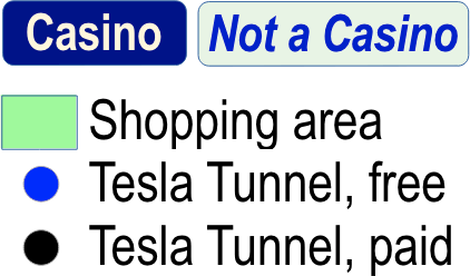
Map is close to scale North-to-South, but compressed West of the Strip.
Changes for this version
General
- Added lots of icons and made the map bigger. The tradeoff is that now it requires more scrolling. I polled readers and they slightly preferred this iconic/bigger map to the text-only/compact map, but since the text/compact map is still very popular, I plan to keep both styles updated.
- Added lots more interactive help. Every item now has it.
- Added a proper legend.
- Using higher resolution, so pinch-zooming doesn’t result in pixelation (unless you zoom really far).
- Switched to WebP format.
- Fixed that annoying problem where a horizontal scrollbar appeared on mobile.
Transportation
- Vegas Loop: Added Encore Station and Westgate Station
- Vegas Loop: Noted which stations are free / paid
- Vegas Loop: Updated ticket prices.
- Monorail: Added Boingo Station and Flamingo Station
- Monorail: Changed route to be more accurate
- Added lots more bus stops, including help, and arrows to show the direction of travel and which side of the street the bus stops.
- Removed bridge markings. They added clutter and weren’t especially helpful.
Other items added
- Gateway Arches
- Bonanza Gift Shop
- Drew the individual Convention Center buildings and labeled them
- Elvis Presley Blvd.
- Shopping areas (nod to Strip Stumble)
Other
- Made major streets thicker. It’s now easier to distinguish street labels from casino labels, so less cluttered.
- Removed labels for defunct casinos Wild Wild West, Landmark, Riviera, and Boardwalk. (No room.) Can still point to those areas or choose from the Defunct menu.
Older versions of my strip map
- (current version)
- 2025-04-28
- 2024-07-17
- 2024-06-12
- 2023-12-13
- 2023-02-21
- 2023-01-18
- 2022-09-28
- 2022-03-26
- 2022-02-19
- 2021-09-27
- 2021-07
- 2020-10
- 2020-02
- 2019-08
- 2011-09-25
- 2011-05-21
Here's my cartoonish map of the strip, but I stopped updating it in 2022.
Maps from other websites
Other Maps of the Strip
- 3D maps with building icons (2020-present). These maps are really cool, with an aerial perspective like you’re looking from a helicopter. (The older maps at Vegas Unzipped look very similar, I think maybe VU did the maps for the Monorail website.)
- Strip Stumble (2025-present). The newest cartographer on the scene has interesting features that other maps don’t, like the locations of drugstores, casino entrances, and indoor walkwalkways that connect casinos.
- Dave Miller Gaming (2025-present). Each casino is depicted with its logo, making it both visually interesting and easy to understand. I used this idea for some of the locations in my own map.
- Google Maps Enhanced (2025-present). Google Maps with the casinos drawn in. They also have detailed info about walking the Strip. Their old map had little circle markers next to the labels for each casino so you could see exactly where they are, which was an inspiration for my earlier map where I did the same thing.
- Hot Mama's map (2025-present). Her old maps had pictures of the casinos in little bubbles, which was very visually interesting. Hur current map is compact and icon-based, but still pretty good.
- CheapoVegas (2013). Their soft design was the inspiration for my cartoonish map, though I stopped updating it in 2022.
- Vegas Today & Tomorrow (2011). A dizzying buffet of maps. Take a look at the Strip with construction since 2003 highlighted in green, or see a color-coded map of which companies own which casinos.
- Historical Map (2007). Shows not just what hotels are on the strip, but which ones used to be there. Of course, that feature is now built into my own map.
Maps of hotel interiors
Vegas strip properties are big. Sometimes you'll need a map to navigate inside the casino! You can see such maps at Vegas Casino Info, though they seem to be from around 2015.
My to-do list
- Consider making bus stops duller
- Add more bus stops
- Add drug stores / convenience stores
- Add more interactive help
- Update the compact map also
- For each casino, add pics, prices, booking links, logo, walk times, casino size, hotel size
- Options to hide dead casinos, buses, etc.
Credit for ferris wheel clip art: Adobe Stock Images